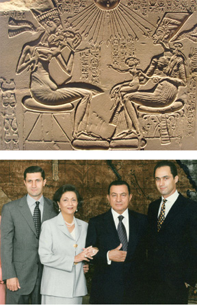
Category Archives: Art

Viewing the Shanamah in Manhattan


Portrait of the infant Rustam shown to Sam (folio 30b)

On Thursday night I had the privilege of attending a reading of portions of the Shanamah by Iraj Anvar.
The reading was held as part of the superb series called “Illuminated Verses: Poetries of the Islamic World,” which is a series of readings and events that began in March with a lecture by Bruce Lawrence on the Quran and continues through May 7. This is an extraordinary opportunity to hear and learn more about the variety of poetic production in Islamic cultures worldwide.

While the reading of the Shanamah is over, you can still see the exhibit of the mid 15th century Muhammad Juki’s manuscript of the Shanamah at the Asia Society through May 1.

New book on Rasulid Yemen


Last month I was invited by historian Eric Vallet to a conference on the Yemeni town of Yaiz in the Rasulid era. Eric has recently published an extraordinary study of the economic system of the Rasulid sultanate in the late 13th century and early 14th century, drawing on the growing corpus of court and tax documents, many of which have been edited by the Yemeni historian Muhammad Abd al-Rahim Jazm. Anyone with an interest in Rasulid Yemen will need to start with Eric’s masterful study. Details on the text, which is in French, are below:

Eric Vallet, L’Arabie marchande. Etat et commerce sous les sultans rasûlides du Yémen (626-858/1229-1454), Paris, Publications de la Sorbonne, 2010 (Bibliothèque historique des pays d’Islam, 1), ISBN 978-2-85944-637-6. Continue reading New book on Rasulid Yemen

A Geography Lesson from 1879: #5: Turkey in Europe


In a previous post I presented an account of the geography of Arabia and Turkey in an 1879 geography school text. Here is the discussion on the European part of the declining Ottoman Empire:

1. TURKEY, constituting the European dominion of the Ottoman Empire, comprises the middle portion of the great southeastern peninsula of Europe.
2. The Climate in some places is severe, but is healthful and favorable to the growth of all the common cereals.
3. The Soil is productive, yielding in abundance the useful grains, tobacco, and grapes, as well as the olive and mulberry. Much attention is given to the culture of plants yielding medicines and perfumes. Continue reading A Geography Lesson from 1879: #5: Turkey in Europe

A Geography Lesson from 1879: #4: Arabia and Turkey


In a previous post I continued a thread from an 1879 school geography text. At the time much of the Arab World was under the control, nominal at times, of the Ottoman Empire. This text divided the Ottoman holdings into those in Asia, discussed below, and those in Europe, to be given in a separate post.

1. Arabia is a great plateau, abounding in deserts, and possessing but few fertile districts, except along the coast. Its area is about 1,000,000 square miles.
2. The Climate is the dryest in the world, rain seldom falling anywhere, and the heat being intense, especially in the lowlands and deserts.
Arabia has been divided into three parts: – ARABIA FELIX, happy or fertile; ARABIA PETRAE, stony; and ARABIA DESERTA, desert. The fist of these divisions borders on the Persian Gulf, the Indian Ocean, and the Red Sea; the second lies on the northeastern shore of the Red Sea; and the third includes all of the central portion of the country. The cultivated tracts are generally near the mountains, from which rivers descend in the rainy season and thus enrich the soil. Numerous oases re found in the desert regions. Continue reading A Geography Lesson from 1879: #4: Arabia and Turkey

A Geography Lesson from 1879: #3: Racial as Facial


In a previous post I provided an account of the five different states of civilization from an 1879 geography text once owned by my great, great aunt. Apparently the author was enamored with the number “five,” since he also divided the human race into five distinct races. Let’s face it, race at the time was a visual matter of face (and hair) and notice in the image above who was in the middle. Here is the breakdown:

“1. The people inhabiting the different regions of the globe have been divided into five varieties, or races; namely, the Caucasian, or European; the Mongolian, or Asiatic; the Ethiopian, or African; the Malay; and the American or Indian.
2. The Caucasians are distinguished for their light complexion and straight hair. They inhabit nearly the whole of Europe, southwestern Asia, and a large part of America. The comprise the most enlightened and civilized nations of the world. Continue reading A Geography Lesson from 1879: #3: Racial as Facial

Ottoman Palestine


A friend recently brought my attention to an Arabic website with a fascinating collection of illustrations and photographs about Palestine under Ottoman rule. I also came across another site with illustrations of Jerusalem in the Ottoman era. I attach two examples here from the latter website, although the site does not specify the source or date of the images. Continue reading Ottoman Palestine

A Geography Lesson from 1879: #2: An Enlightened National View of the Others


I recently started a thread on a school geography book from 1879. At that time the idea of “civilization” was fixed in a hierarchy. According to Lesson XXI (States of Civilization), there were degrees for separating out the inhabitants of the earth. Here is the sequence, with the student no doubt informed in the classroom that the United States was the most enlightened:

1. Nations, with regard to the degree of their civilization, are divided into five general classes: Savage, Barbarous, Half-civilized, Civilized, and Enlightened Nations.
2. Savages
dwell in tribes; they live in caves, dens, or huts, and are chiefly occupied in hunting, fishing, or war.
3. Barbarous Nations live in larger communities than savages, practice some rude arts, attend to the rearing of flocks and herds, and in some cases, till the soil.
4. Half-civilized Nations
have organized governments and dwell in cities, occupy themselves in agriculture and mechanic arts, but are without education, refinement, or morality.
5. Civilized Nations are such as have made considerable progress in knowledge and morality, have good governments and generally wise laws.
6. Enlightened Nations
are such as hold the highest rank in intelligence, scientific progress, and moral, religious, and social culture.

Excerpt from: Colton’s Common School Geography (New York: Sheldon and Company, 1879), 17.

to be continued

A Geography Lesson from 1879: #1: The Earth is not a Plain


Once upon a time Geography went right along with the three r’s in the school curriculum. I have a copy of the geography text my great, great Aunt Ida used. This was Colton’s Common School Geography illustrated by numerous engravings and twenty-two study maps, drawn expressly for this work, and specially adapted to the wants of the class-room, to which are added two full-paged railroad maps, showing the chief routes of travel, and a complete series of twelve commercial and reference maps of the United States. It was published by Sheldon and Company, located at the time on 8 Murray Street in New York, in 1879.

In 1879, when my discipline of Anthropology was still in academic diapers, Geography was defined as “that branch of science which describes the surface of the earth, the divisions and inhabitants” (p. 3). Apparently back then it was still important to show why we knew the earth was not flat. As the text explains:

We know that the earth is not a plain, because 1. Navigators have sailed around it; 2. The upper portions of objects at a distance, as a ship at sea, are seen before any other part; 3. The shadow of the earth, as seen at the time of an eclipse of the moon, has always the form of a circle or a segment of a circle. (p. 3)

In discussing land divisions some 20 different kinds are listed, including a desert (“a tract of land nearly or quite barren”) and an oasis (“a fertile spot in the desert”) with both of these rating an illustration as shown above.

to be continued