The Bodleian Library in collaboration with The Oriental Institute, University of Oxford, announces the electronic publication of The Book of Curiosities of the Sciences and Marvels for the Eyes, a newly discovered medieval Arabic treatise on the depiction of the Heavens and the Earth. The treatise is one of the most important recent finds in the history of Islamic cartography in particular, and for the history of pre-modern cartography in general. The publication of the treatise is mounted on a dedicated website employing a new method for publishing medieval maps.
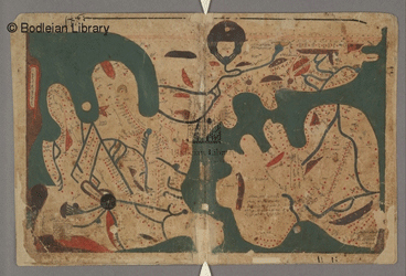
The Book of Curiosities is an illustrated anonymous cosmography, compiled in Egypt during the first half of the 11th century. The only known copy of this manuscript, probably made in the late 12th or early 13th century, was acquired by the Bodleian Library in 2002. The manuscript contains a unique series of maps and diagrams, most of which are unparalleled in any other medieval work. These include diagrams of star-groups and comets; a rectangular map of the world with a graphic scale (the earliest surviving example of such a map); a circular world map; individual maps of islands and ports in the eastern Mediterranean, including Sicily, Tinnis, Mahdia, Cyprus, and the Byzantine coasts of Asia Minor; maps illustrating the Mediterranean Sea as a whole, the Indian Ocean, and the Caspian Sea; and maps of five major rivers (the Nile, Indus, Oxus, Euphrates, and Tigris). The website contains an electronic high-quality reproduction of all the folios of the original manuscript, linked by mouse-overs to an Arabic edition and an annotated English translation of the text of the treatise as well as the labels on the maps. The site also allows users to search for English and Arabic terms, consult an extensive glossary, and study explanatory diagrams. The treatise is available in its entirety except for five chapters from Book 1 on astronomy and astrology that will be available shortly.
This is the first electronic publication of a work of medieval Islamic cartography, promoting research in a relatively neglected field. It is also intended to be widely used as a teaching tool in graduate and undergraduate courses on Islamic history, Islamic culture, and the history of science. For younger students, the website contains a downloadable Teacher’s Pack based on portions of the manuscript, suitable for Key Stage 3 of the UK National Curriculum (aimed at 11-14 year olds).
Emilie Savage-Smith and Yossi Rapoport, Oriental Institute, University of Oxford.